Ecology Matters Trust funding leads to successful £220,000 grant to use Drones to survey cetaceans from Bardsey Island (Enlli)
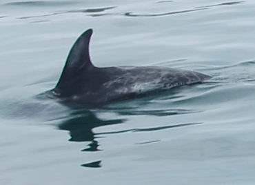
Since the mid 1990’s surveys of cetaceans have been undertaken on Bardsey (Enlli) island. These surveys recorded all dolphins seen but in particular Risso’s Dolphins. This is a poorly understood species in UK waters, but individual animals can be identified from the marks on their dorsal fins. Surveys consisted of shore-based surveyors spending a week on the island, on the cliff tops, searching for cetaceans on the water, and if seen trying to launch a boat to get close enough to photograph fins. This was always problematic. The surveys were latterly undertaken by Whale and Dolphin Conservation but ceased in 2019 due to lack of funding.
In 2021 and 2022, the Trust funded Mick Green to lead a team to return to the island, with two drones and experienced, qualified drone pilots to evaluate if drones could be used to fly to locations where cetaceans were spotted and gain video and still photographs of the animals. This would allow individual dolphins to be identified with greater precision. This pilot study proved very successful, with high resolution video and images obtained. Drones can be launched immediately on spotting the dolphins, and do not disturb the animals in the way that boats do. Based upon this success, Mick Green, with Bardsey Bird and Field Observatory, submitted a grant application to the Welsh Government’s Nature Network Fund (through the Heritage Lottery Fund), to employ a field worker to be based on Bardsey for the summer months to use a drone to identify individual cetaceans. This application was successful and a grant of £220,000 was obtained. In addition, to the drone work, the field worker will be using software to identify individuals based on photographs of fins, from Bardsey and from historic records in Cardigan Bay and the area around Bardsey to build a detailed picture of cetacean populations and distribution. The grant also funds a part time worker based upon the mainland to engage in community work to highlight the importance of cetaceans and wildlife around the coast of north Wales.
The success in gaining Heritage Lottery Funding clearly demonstrates the value of Ecology Matters Trust funding ecological survey work and evaluating the usefulness of new methods of ecological surveys.
Further details and updates: http://bbfo.blogspot.com/p/bardsey-marine-mammal-project.html and https://vimeo.com/761242765
Movement of GPS tagged curlew in mid – Wales
In common with much of the UK and many other parts of Europe, the Eurasian curlew is in significant decline both numerically and spatially, a result of a combination of three significant pressures: habitat loss, unfavourable habitat management and nest/chick predation The curlew is a highly migratory species in urgent need of coordinated UK and Wales conservation action. In the absence of contemporary survey data, estimates of the Welsh curlew breeding population range from 400 to no more than 1,700 breeding pairs Breeding Bird Survey (BBS) data indicate that the breeding population of curlew in Wales is declining at a rate of 6% per year.
Curlew is a species of urgent conservation concern in the UK and Wales and is now globally Near-Threatened due to widespread declines across the breeding range. Owing to rapid national declines, the global importance of the UK breeding population, and that curlew is predicted to be on the brink of extinction as a viable breeding species in Wales by 2033 the curlew is now considered to be the most pressing bird conservation priority in the UK including Wales.
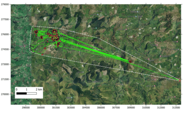
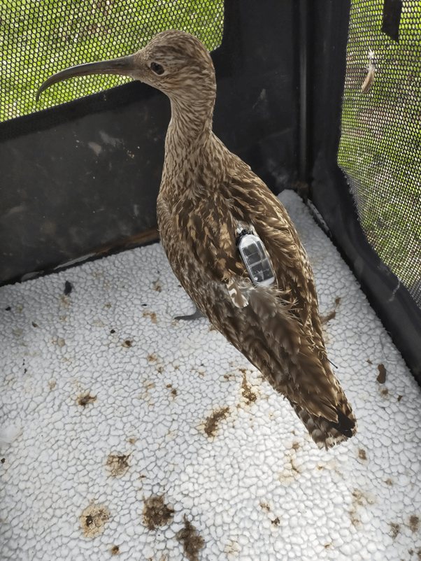
In 2022, ten individual curlew were fitted with Global Positioning System (GPS) tags(under licence) in Montgomeryshire and on the Fenns Whixall NNR just before the breeding season. This was undertaken by Tony Cross, assisted by Mick Green with funding from Natural Resources Wales, who also funded an analysis of the first year of data. Several of the tags continued transmitting during 2023 providing another year of data. Funding for the analysis of this further year was provided by The Ecology Matters Trust.
The following is an initial summary of the results, showing curlew utilise a wide range of favoured fields in the breeding season, with implications for conservation management.
Summary
- Based on the clustering of GPS location points at potential nest sites, location data were used to partition the breeding season into three time periods: pre-breeding, nesting and post-breeding.
- GPS data suggested that nine out of the ten tagged birds incubated eggs, with two birds incubating a second clutch and one bird incubating a third clutch (13 nests in all).
- Of the nine birds incubating eggs, the GPS data suggest that four clutches likely hatched (44.4% of nine individuals, but 30.8% of 13 nests).
- GPS data provided less information on ultimate breeding success (e.g., chicks fledging). However, short periods of chick guarding by three GPS-tagged curlews suggest that it is unlikely that any chicks fledged. The nesting failures inferred from the GPS data highlight the poor breeding success suffered by curlew nesting in east Wales.
- Mean core and total home range sizes, defined using a 50% and 95% kernel density estimator (KDE), during the nesting period, were small (mean +SE = 4.7 ha +0.7 ha and 53.8 ha +9.7 ha respectively) and varied slightly during the breeding season (April to July). There was inter-individual variation in home range size.
- However, both during the nesting period and the time between nesting periods, the curlew ranged widely either for roosting or feeding. The mean ‘landscape footprint’ of the curlews, defined as the total area occupied using Convex Hull geometry was much larger (mean +SE = 23,052 ha +6,597 ha).
Analysis of the GPS location data with Phase 1 habitat data (in Wales) and Land Cover Map habitat data (in England) showed variation in habitat selection between individuals. Improved grassland and wet heath were preferred in all three time periods (pre-breeding, nesting and post-breeding). Arable land and bogs were preferred during the pre-breeding and nesting periods, but avoided during the post-breeding period. Flush/mire was preferred during the nesting period but avoided in the pre- and post-breeding periods. All other land use categories were avoided to a greater or lesser degree.
Whilst providing insights into the breeding habits and land use of curlew in east Wales, this analysis reveals the limits of relying on telemetry data to define nest site selection and breeding outcome. GPS data from future marked curlew should be complimented with dedicated fieldwork.